Roadway and Parking Lot Design
Description
One of the simplest ways to cut down on stormwater runoff is to reduce the amount of impervious cover associated with roadways and parking lots. Careful design is the key to reducing pavement while still providing good site access and adequate parking. Good road and parking lot design can also create opportunities for decentralized stormwater management in bioretention areas, roadside swales, and infiltration structures. Basic strategies for road- way design include low-impact roadway layouts, narrow road widths, shared driveways, and open-section roadways. Parking lots designers should look at strategies to break up large parking lots, maximize shared parking, rethink parking requirements, and use permeable paving where appropriate.
Alternative road and parking designs may offer cost savings for developers, because there is less pavement to construct and less stormwater runoff to treat. In some cases, more compact parking may allow higher site densities. The primary impediment to these strategies may be resistance at the permitting stage. Many communities stringently enforce elaborate and often excessive roadway and parking standards in an effort to prevent development. Developers, advocates, and regulators who understand the benefits of Low Impact Development need to work together to point out that alternative designs can provide safe access and sufficient parking, as well as environmental and aesthetic benefits.
Applications and Design Principles
Roadway Width Excessively wide streets are the greatest source of impervious cover (and stormwater runoff ) in most residential developments. Some local codes require streets up to 40 feet wide in sub- divisions with only a dozen houses. These inappropriate standards result from blanket application of high volume/high speed road design criteria, overestimates of on-street parking demand, and the perception that wide streets result in faster emergency response times.
Narrower road sections and alternative road profiles can reduce stormwater runoff and mitigate its impacts, while still allowing safe travel, emergency vehicle access, and adequate parking. For most low-traffic roads, a 24-foot road width is sufficient to accommodate two way traffic, and even narrower widths should be used in very low traffic conditions (e.g., a six-lot subdivision.) The National Fire Protection Administration Uniform Fire Code (2003) recommends a minimum unobstructed width of just 20 feet, with the recognition that local authorities can set lower standards if turnouts or alternate exits are available.
In order to achieve the environmental benefits of narrower street widths, regulators must make clear that they are willing to adjust site design standards to provide developers with the opportunity to try alternative designs. One preliminary step is to require parking on one side of the street only. This is appropriate where most houses have off–street parking. Design standards can also allow parking lanes or road shoulders made of permeable paving, such as grass pavers or paving blocks.
Some communities are moving to roadways that use a single travel lane and one or two "queuing lanes," which can be used for either parking or travel. This strategy can reduce street width by a third, and it does not affect travel except when two cars need to pass each other at the spot where a third car is parked, in which case one car pulls into the queuing lane until the oncoming car has passed. Research indicates that "tight streets" actually improve traffic safety by encouraging vehicles to slow down in residential neighborhoods. Through- out Massachusetts, many older neighborhoods built before current standards were enacted have narrow streets that function well, calm traffic, and lend character to the community.
Roadway Profile
Curbs and gutters concentrate stormwater runoff and increase its velocity, impeding decentralized treatment and infiltration. LID strategies recommend open-section roadways flanked by filter strips and swales instead of curbs and gutters. These LID techniques, built on the model of "country drainage," help to filter roadway runoff, promote infiltration, and reduce runoff velocity, resulting in lower peak discharge rates. If properly designed, open section roadways will be no more prone to flooding than conventional roadway profiles. If curbs are deemed necessary to stabilize the roadway edge, the design can use invisible curbs (same level as the road surface), periodic curb cuts, or perforated curbs to allow stormwater to run off the roadway edge.
Roadway Layout
The location and layout of roadways can also be modified to improve post-development hydrology. Roadways should be placed to avoid crossing steep slopes where significant cut and fill will be required. They should run parallel to contours on gentle slopes and perpendicular to contours on steeper slopes. Design of a roadway network may involve some give and take between reducing total roadway length and road layouts compatible with existing topography. On low-speed streets, clearing and grading should be limited to a small strip of land (5’) on either side of the roadway and sidewalk.
In residential subdivisions, shared driveways can reduce site development costs as well as impervious surface coverage. Property owners will also realize some savings through shared snow plowing costs. Driveways can be limited to 9 feet in width. They should be sloped or crowned so that they drain evenly onto adjacent vegetated areas (not onto the street) where the runoff will infiltrate or travel via sheetflow.
Turnarounds and Cul-de-Sacs
Many residential streets end in large cul-de-sacs up to 80 feet across, which generate large amounts of runoff during storms. Alternative designs can reduce runoff and improve neighborhood character, while still providing sufficient room for fire trucks and school buses to maneuver. One simple approach (applicable to both new construction and retrofits) is to create a landscaped island in the middle of a standard-size cul-de-sac. A 30-foot island in an 80-foot diameter cul-de-sac will reduce the impervious surface by 15%; if the island is designed and built as a bioretention area, and the roadway graded appropriately, this strategy can also treat roadway runoff.
Other design changes can produce even greater benefits. Reducing the radius of a cul-de-sac from 40 feet to 30 feet yields a 45% reduction in paved surface (5,000 sq. ft versus 2,800 sq. ft.) A T-shaped hammerhead occupies even less space but still provides sufficient room for turning vehicles and fire trucks (though it may require a 3-point turn.) Depending on the length of the street, designers should consider a one-way loop road with parking on one side. Cul-de-sac design is definitely one area where regulatory standards prevent creative designs; regulators should consider re-wording their regulations to replace geometric standards with performance standards.
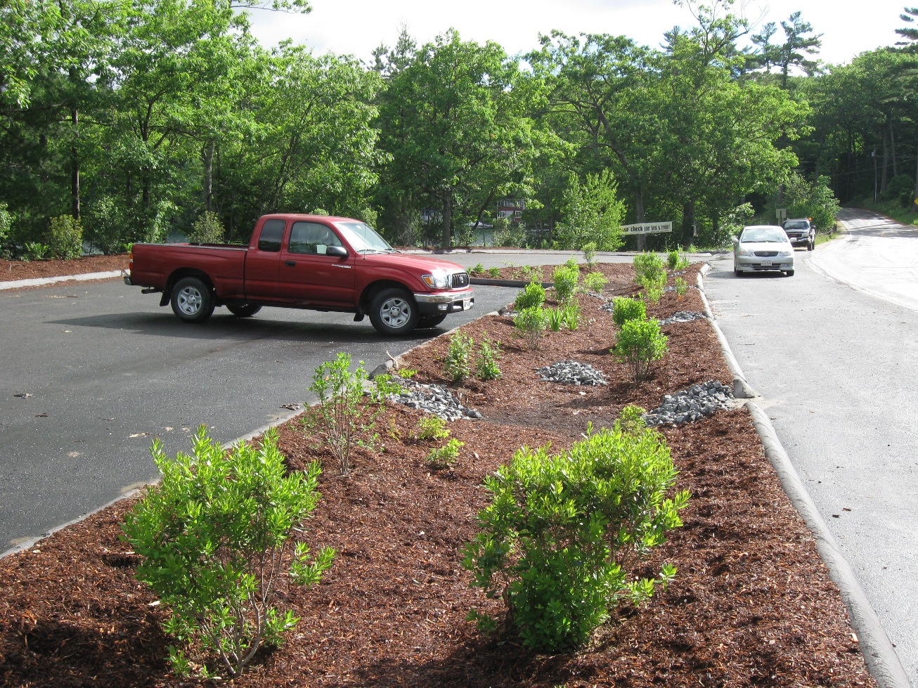
Parking Lots
Expansive parking lots that drain to just a few catch basins create large volumes and high velocities that require the use of pipe-and-pond stormwater techniques. The LID approach encourages designers to create multiple smaller parking lots separated by natural vegetation and bioretention areas. On hilly sites, the creation of multiple parking areas at different elevations can reduce the amount of grading necessary and preserve natural hydrology.
Permeable paving is rarely appropriate for use in high traffic parking lots, but some success has been found with hybrid parking lots, which use conventional paving for driveways and aisles, and permeable paving for stalls. Permeable paving may also be appropriate for over- flow parking areas, which are generally used only a few weeks out of the year.
Other strategies include reducing the total number of parking spaces and reducing the size of some parking spaces. Many communities have provisions for shared parking, so that mixed use developments, or single use developments near other uses, can share parking according to a formula based on the peak demand periods; residents use the parking spaces at night and customers or employees use the same spaces during the day. Parking spaces designed for compact cars can also help to limit impervious coverage.
Considering the aesthetic and environmental impacts of large parking areas, community boards might consider parking maximums, as well as parking minimums, in order to prevent oversized parking lots and ensure that supply is in line with demand.
Benefits and Effectiveness
Narrower roadways, smaller parking areas, and smaller stormwater management systems result in lower site development costs.
A hierarchy of streets sized according to daily needs yields a wide variety of benefits: lower average speeds, more room for trees and landscaping, improved aesthetics, and reduced heat island effect.
Designs that reduce the amount of parking and break it up into multiple smaller lots separated by vegetation create more attractive developments.
Limitations
Alternative roadway and parking designs may conflict with local codes, which often have strict requirements for road widths and drainage systems. However, many boards may be willing to adjust their standards if developers, advocates, and neighbors support the alternative design.
Emergency service access is a common concern with reduced street widths. Where possible, these concerns can be addressed through education or multiple points of access to a site.
Cost
Narrower streets and smaller parking lots cost less than conventional streets because less
grading, base material, and pavement is required. Open section roadways cost considerably less than standard designs due to the elimination of curbs and gutters.
This fact sheet was adapted from the Massachusetts Low Impact Development Toolkit, a production of the Metropolitan Area Planning Council, in coordination with the I-495 MetroWest Corridor Partnership, with financial support from US EPA. The Massachusetts Low Impact Development Interagency Working Group also provided valuable input and feedback on the LID Toolkit. For more information, visit
www.mapc.org/lid and
www.arc-of-innovation.org.
References
A Policy on Geometric Design of Highways and Streets, 5th Edition; American Association of State Highway and Transportation Officials, 2004
Shared Parking Guidelines; Institute of Transportation Engineers, Washington DC; 1995. The American Planning Association (
www.planning.org) has published a variety of reports on parking standards, as part of its Planners Advisory Service.